Happy GIS Day! Geographic Information Systems (GIS) is a powerful information tool facilitating the development of data-based solutions. GIS professionals use this tool to translate complex data into powerful visualizations.
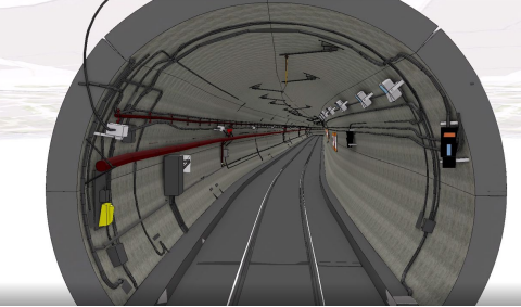
On behalf of the Central Puget Sound Regional Transit Authority (CPSRTA), DEA performed a 3D laser scan survey (LIDAR) of the Downtown Seattle Transit Tunnel from King County Metro to the CPSRTA. Our GIS and survey professionals created a Revit model (BIM) directly from the laser scans and developed an interactive webmap for viewing of the 360 photos taken throughout the 1.4 mile long tunnels and multi-leveled facility.
The webmap proved to be one of the most useful tools for the owner and project team. The project resulted in saving valuable time on site visits by providing the ability to look around the facility from their desktop computer and mobile device.